La Crosse, WI to Richland Center, WI
Distance: 78.7 miles
Total trip distance: 1760.4 miles
Average speed: 12.4 mph
Maximum speed: 39.2 mph
Riding time: 6:18
Weather: at our 8am start it was about 60 degrees and the wind was mostly northwest at about 8 mph and got slightly stronger later in the day. The hilly terrain mostly negated wind effects. The air was dry with a dew point in the high 40s. The temperature warmed to the upper 60s on a mostly cloudy day.

This day is the third and final day that Tom rode with me. Each of the three routes we did repeated ones from earlier trips. The routes on the first two days duplicated those of a 2001 trip to Dubuque, Iowa, and today's route matches the third day of our 2007 ride to Madison, WI. Tom is an organized guy, and I was not surprised that he produced backup copies of maps from years earlier. This saved us a lot of work. Much time and effort goes into planning routes because we try to avoid busy roads and use paved back roads. Today's route avoided US 14 and US 61. We were mainly on lightly used county roads, except for the first dozen miles or so out of La Crosse. The biggest town of the day, except for the start and finish, was Viroqua, with a population of about 4,300 people. We often rode side by side, something we could not do as much on the first two days.
A major reason we were mostly alone on the roads is that we were in the Driftless Area, an unglaciated zone of rugged topography with deeply carved river valleys. Drift in this context refers to silt, clay, sand, gravel, and boulders deposited by glaciers. The Driftless Area in Wisconsin and neighboring states (see map below) has few of these deposits, and in addition, glaciers did not smooth out the terrain, leaving it rugged and with fragile looking outcrops. Some of the valleys reach a depth of 500 or 600 feet, as we personally experienced. We entered the Driftless Area the day before, as evidenced by several of the photos showing steep bluffs.
We left the northern section of La Crosse and headed toward downtown with a lot of commuters. After a couple of miles of traffic we got off the main road and stuck closer to the river in an industrial and railroad district.
About a dozen miles south of La Crosse we veered inland and rode several miles uphill along Chipmunk Coulee. In Wisconsin, coulee refers to a steep-sided valley. Much of the Driftless Area is too rugged for row crops, but the uplands have some crops and pasture, and some of the fields are contoured. The land was too uneven for straight roads of any length.
Tom noted that this part of Wisconsin has a disproportionately high percentage of organic farmers. In Chaseburg we saw a creamery run by Organic Valley. We had a delicious lunch at the Viroqua Food Coop Market and Deli, where they emphasize local and organic food. It was an impressively large and well run operation for a town of 4,300 people. Well maybe not well run in every regard. Tom got a newbie employee and had to wait awhile for his panini.
Viroqua seemed like a prosperous town. It's a county seat, an agriculture service center, and supports several art stores with the name "Driftless" in them. We passed through another town starting with a "V," Viola. It only has about 800 people and is not doing so well. When we went through it eight years ago, we enjoyed the sign below, but alas, the sign is now gone.
Pam drove to Richland Center to pick up Tom. We had a decent meal at a nearby Mexican restaurant. As Pam noted, this dinner did not compare favorably to most of our other bike trip completion dinners, which are usually at a fancy restaurant. Pam makes great dinners for us before we leave Minneapolis for bike trips. A few days ago she prepared shrimp linguine and fresh slices of tomatoes with balsamic vinegar and herbs. The fresh Colorado peach pie a la mode was so good that I proposed canceling the trip and just eating peach pie instead.
I was sad to see Tom and Pam go after they dropped me off at the motel in Richland Center. It was the same one we stayed in eight years earlier. I stood there for some moments as they drove away. This three-day trip was one of the best Tom and I have ever done, and it probably had the best weather. It's hard to top three days of tailwinds with unseasonably cool temperatures and no threat of rain. Tom and I and bikes go way back. In the early 1970s we organized small group rides of five or so from south Minneapolis to a lake 25 miles away and then back. Beginning with Tom's proposal of a trip to Fargo, ND in 1996, we have done eighteen trips in the last two decades. That is a lot of time together in close quarters--enough time to make each other crazy. In a recent bike blog recording a cross country tour by two buddies for the Minneapolis Star Tribune, Tony Brown wrote that "Fifer and I have known each other many years and have ridden many miles, but we each discovered new and profound ways that the other is annoying." I can say that Tom is not annoying. Well maybe there are two exceptions. He is exceedingly well prepared and cautious--after more than 70 straight motels accommodated our bikes, he still checks with the motel each time. I of course don't, and look what happened at the Pepin Motel (see Day 29 post). He was right again. The other annoying thing is that I have a fancy new bike and his tour bike is a banged up 15-year old LeMond, but he still glides down hills faster than I do. I have to pedal with some effort to keep up with his downhill glide. Sometimes I catch some effortless gliding in his draft though. That's what friends are for, right? I figure he owes it to me. After all, I am older. If I remember correctly, I was born on 7am, August 11, 1951 and he was born about an hour later.
Terrain: uphill 4170 feet, downhill 4065 feet. These are the highest numbers for my entire trip. The profile below shows that after we left the Mississippi River Valley around the 12-mile mark we had several uphills and downhills of about 500 feet of vertical.
 |
| Google map showing our route from La Crosse to Richland Center. The largest town of the day, Viroqua with about 4,300 people is at the halfway point. |
 |
| This landform map by Erwin Raisz shows most of the Driftless Area, although portions in Wisconsin, Illinois, and Iowa are missing (to see the missing bits, go to the Raisz map). La Crosse is on this map, but our terminus, Richland Center, is not--it is in the river valley below the "E" of the word "Area." |
 |
Orange flames against a blue sky in an industrial district along the Mississippi River near downtown La Crosse.
|
 |
Trains rolled by frequently, sometimes several times an hour, when we were near the Mississippi River today and on the previous two days..
|
 |
Contoured corn field, that is, the corn roughly follows contour lines of equal elevation.
|
 |
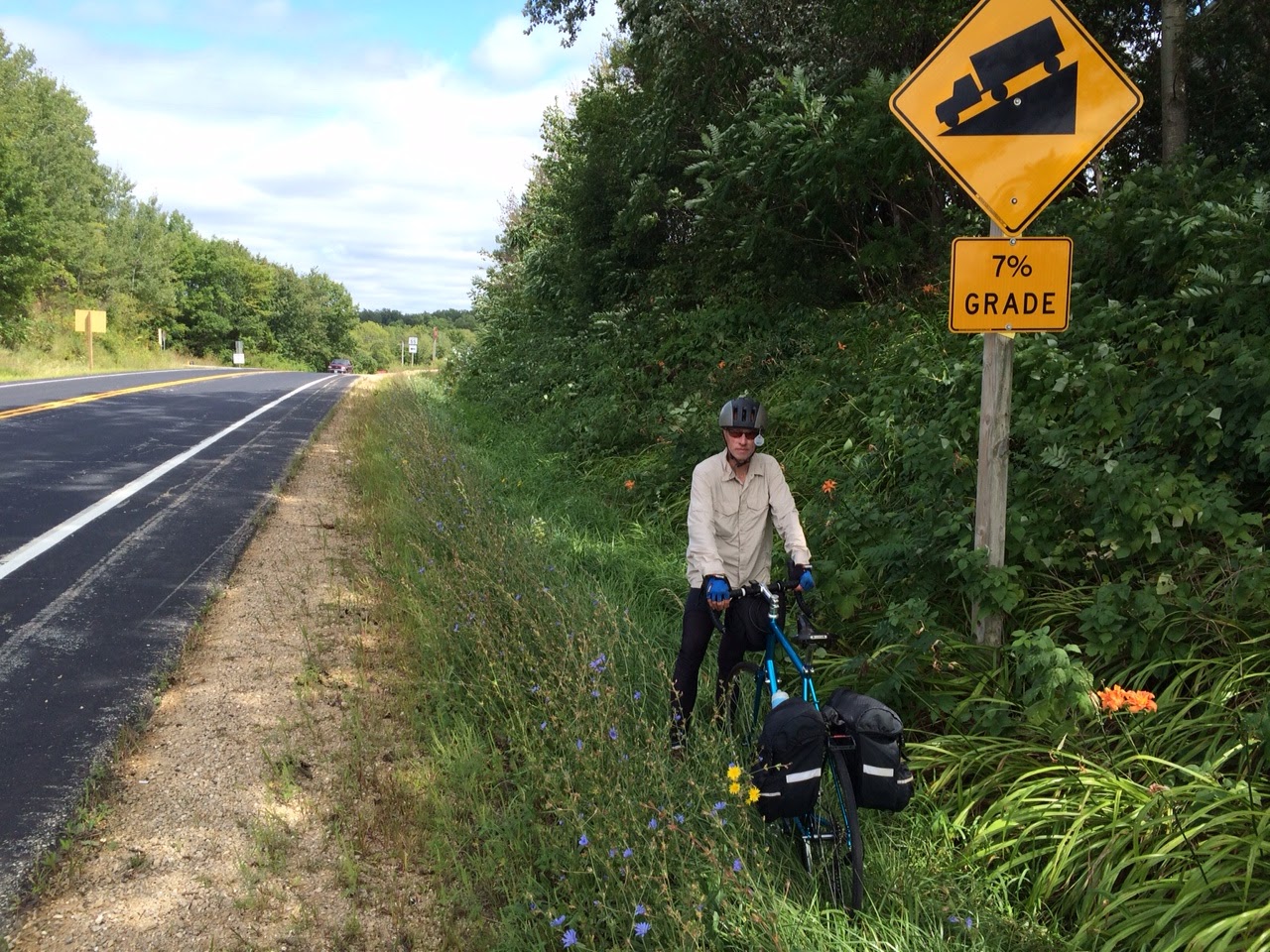
Uh oh--looks like a steep and winding climb.
|
 |
We just huffed and puffed up this long and winding hill behind Tom.
|
 |
We got to go down this hill. Some of the hills were steep enough that we had to squeeze the brakes a little to stop from careening off the road.
|
 |
Puffy white clouds, blue skies, and a tail wind. The wind sock shows a northwest wind of about 5 mph. The wind helped us out when we were in open areas in the uplands.
|
 |
Organic Valley's Chaseburg Creamery.
|
 |
We recommend this coop for tasty food.
|
 |
Viroqua promotes world peace. This memorial is on Viroqua's Main Street.
|
 |
Flashback! A picture from our 2007 trip shows Tom in Viola. On the current trip eight years later, he is wearing the same neon yellow jersey.
|
 |
We end the day's ride in Richland Center, and stop by the Richland County Republicans office. We think they should have the same sign shown in the previous photo posted on the building. No, just kidding, no political humor here.
|
I was sad to see Tom and Pam go after they dropped me off at the motel in Richland Center. It was the same one we stayed in eight years earlier. I stood there for some moments as they drove away. This three-day trip was one of the best Tom and I have ever done, and it probably had the best weather. It's hard to top three days of tailwinds with unseasonably cool temperatures and no threat of rain. Tom and I and bikes go way back. In the early 1970s we organized small group rides of five or so from south Minneapolis to a lake 25 miles away and then back. Beginning with Tom's proposal of a trip to Fargo, ND in 1996, we have done eighteen trips in the last two decades. That is a lot of time together in close quarters--enough time to make each other crazy. In a recent bike blog recording a cross country tour by two buddies for the Minneapolis Star Tribune, Tony Brown wrote that "Fifer and I have known each other many years and have ridden many miles, but we each discovered new and profound ways that the other is annoying." I can say that Tom is not annoying. Well maybe there are two exceptions. He is exceedingly well prepared and cautious--after more than 70 straight motels accommodated our bikes, he still checks with the motel each time. I of course don't, and look what happened at the Pepin Motel (see Day 29 post). He was right again. The other annoying thing is that I have a fancy new bike and his tour bike is a banged up 15-year old LeMond, but he still glides down hills faster than I do. I have to pedal with some effort to keep up with his downhill glide. Sometimes I catch some effortless gliding in his draft though. That's what friends are for, right? I figure he owes it to me. After all, I am older. If I remember correctly, I was born on 7am, August 11, 1951 and he was born about an hour later.
Jim, I was born in the afternoon on August 11, 1951. You are many hours older than I. I, theredore. rely on that wisdom you posses :-) -- Tom
ReplyDelete